


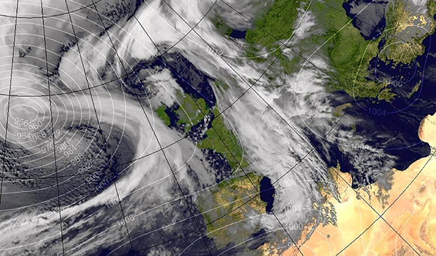
IMAGE CREDIT: Met Office
9:06am: Storm Doris is here in Pevensey Bay, stay safe—Bay Life, 23 February 2017
Residents woke up to a punch this morning as Storm Doris hit Pevensey Bay.
Very strong bursts of gusts that stop and then stab and then rise and swirl very quickly, disturbing the air with audible roars and gushes that sound like a steam train is about to come through walls. And then seconds later, nothing. A time to stay safe indoors. The doors feel like they want to move on the hinges.
Wind speeds with gusts of up to 71.4mph recorded on the Pevensey Bay Live Weather Display. In the last hour the avergae speed is 42.6mph.
Suddenly the wind seems to disappear in a second and then return as background noise. The lulls in between are marked by a strange heavy rain with big vertical gaps between the lines, if that makes sense at all. All very strange.
This is an odd, wild storm and Doris is very unpredictable. The storm has swung into Pevensy Bay and yet the sun is trying to shine through.
Alarming range of pushing power and not much sign of anyone daring to walk the walk outside on the roads.
Stay safe this is a dangerous stranger in town.
Local resident, Odette Ryan-hoare commented, “just had a lovely dog walk on the beach but did almost get blown away lol sunny and not cold but the sea very grey and big waves”.
Jane Beej Ranger, who lives in Normans Bay said, “pretty hairy on the platform at Norman’s Bay this morning, shelter is damaged”.
Esatbourne Buzz is recording that Network Rail has imposed speed restrictions across the Southern network owing to the predicted strong winds. Coastal routes will see a 50mph speed restriction in place between 8am-5pm, with the rest of network hit between 12noon-5pm. As a result, there will be changes to some Southern and Gatwick Express services, meaning delays and cancellations are possible on all routes south of East Croydon.
The BBC explains that Storm Doris is caused by a “weather bomb” – a very intense area of low pressure which “explodes” when it travels underneath a powerful jet stream.
The Met Office provides this definition of a weather bomb.
A ‘weather bomb’ is not a perfect meteorological term but is defined as an intense low pressure system with a central pressure that falls 24 millibars in a 24-hour period. A better description can be more directly linked to the meteorological phenomena known as rapid or explosive cyclogenesis. This is where dry air from the stratosphere flows into an area of low pressure. This causes air within the depression to rise very quickly and increases its rotation, which in turn deepens the pressure and creates a more vigorous storm
Met Office
National Severe Weather Warnings
London & South East England
Issued at: 08:00 on Thu 23 Feb 2017 by Met Office
Amber warning of wind
“Some very strong winds are expected on Thursday in association with storm Doris with gusts of 60-70 mph likely, and 70-80 mph on coasts and hills”.
“Whilst the strongest winds look to be only short-lived, damage to structures, interruptions to power supplies and widespread disruption to travel networks are likely, with a danger of injury from flying debris. Trees are also likely to be damaged or blown over”.
“Heavy rain is also likely through Thursday as well as some snow over high ground as the system clears eastwards. These may prove additional hazards”.