


The further South we are the stronger the wind will be, is what is forecast today (Sunday 6 February) for the coming day. We are not in Cornwall, but the results are demonstrably of concern.
Talk is of wind lashing the coast with the worst affected areas in the South West.
Windy enough in Pevensey Bay, wind speeds up up 27mph this evening with gusts up to 39mph, with what can only be described as a light lashing of rain which is visibly affecting the movement of people out and about, with few signs of dog walkers or anyone on anything other than important errands and needing to travel.
One dog walker who ventured out mid morning when there was a small stretch of Sun reported to Bay Life that she “only saw one other person out, and I was out for nearly an hour “and that “walking against the wind was hard, but not as hard as yesterday”.
Same pattern yesterday, when mid evening wind speeds and gusts appeared to have been about the same strength. The sporadic nature of the wind and rain is not nice at all, with the sudden rushing sound of the wind picking up speed spontaneously and without warning.
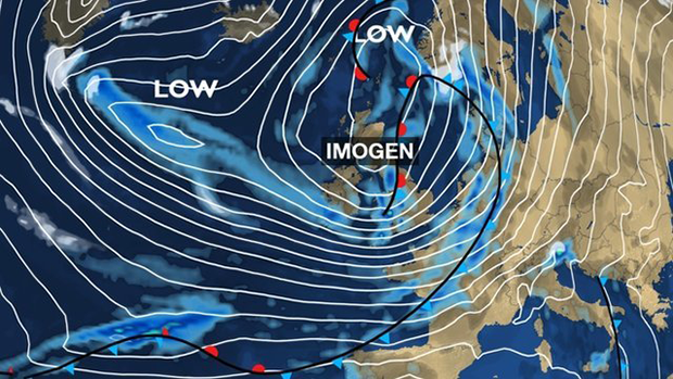
It seems yet more to come, possibly worse, in next few days as Storm Imogen takes hold.
Time yet again for us to batten down the hatches.
East Sussex currently has an amber warning issued by the Met Office
From: 0300 on Mon 8 February
To: 1800 on Mon 8 February“An area of very strong winds is likely to extend east across southwest England and parts of central southern England on Monday morning. Gusts of 60-70 mph are likely widely, with 80 mph gusts in exposed coastal areas, particularly Cornwall and North Devon, and also through the Bristol Channel. Some very large waves are also likely to affect many coasts, in particular north coasts of Cornwall and Devon.”
“Winds should gradually ease through the afternoon and evening. Please be prepared for disruption to travel as well as possible damage to trees and structures, and interruption of power supplies.
“This is an update to the warning to extend the amber area to cover more of the Bristol Channel, including Cardiff and Bristol, and also English Channel coasts of Sussex and Kent”.
Gusts may reach 80mph, with high winds sweeping across the Bristol Channel area to Cardiff and Bristol from the early hours, reports the BBC.
Met Office forecaster Craig Snell added, “The wind will be combined with some hefty showers with some thunder along the south coast.”
He also indicated that the morning rush hour would be “especially impacted”.
Southern Trains have warned that there may be “some service alterations” from late Sunday until Monday afternoon.